PICTUREE: Aedes
Vector-borne diseases result from, for example, virus, parasite, bacterial, or rickettsial pathogens transmitted to humans from the bite of an infected mosquito, biting fly, sandfly, or tick arthropod vector. The US military repeatedly suffers mission degradation from vector-borne disease during contingency operations, with medically-related reductions in personnel ranging from 10-50% depending on the theater of operation and available countermeasures. The current global distribution of joint US military forces supports faster and larger deployments to numerous diverse environments that complicate exposure risks. The Deployed War-Fighter Protection research program continues to invest in tools and products that protect troops from nuisance and disease-vector arthropods and increase combat readiness. However, the US military does not have an unlimited budget nor the ability to provide all materials to all locations. A decision support tool is needed to optimize locale-specific provisioning, alignment, and timing of vaccine, prophylaxis/treatment, personal protection, vector control, and disease/vector surveillance resources based on estimated risk for transmission of vector-borne pathogens.
Here we are developing an innovative and unique system to close this capability gap, the PICTUREE (Predicting Insect Contact and Transmission Using histoRical Entomological and Environmental data) logistical support tool. Estimating current and future pathogen transmission risk will reduce waste of limited shelf-life products and increase logistical efficiency to hub and forward areas. Planners will use PICTUREE software to determine a Service Member's likely current and future risk based on geographic location, the season of deployment, and estimated time in the country. Furthermore, the software will allow commanders to monitor in-country conditions to decide when and which products to (re)order and, following redeployment, medical providers can evaluate likely past exposure to help with clinical diagnosis.
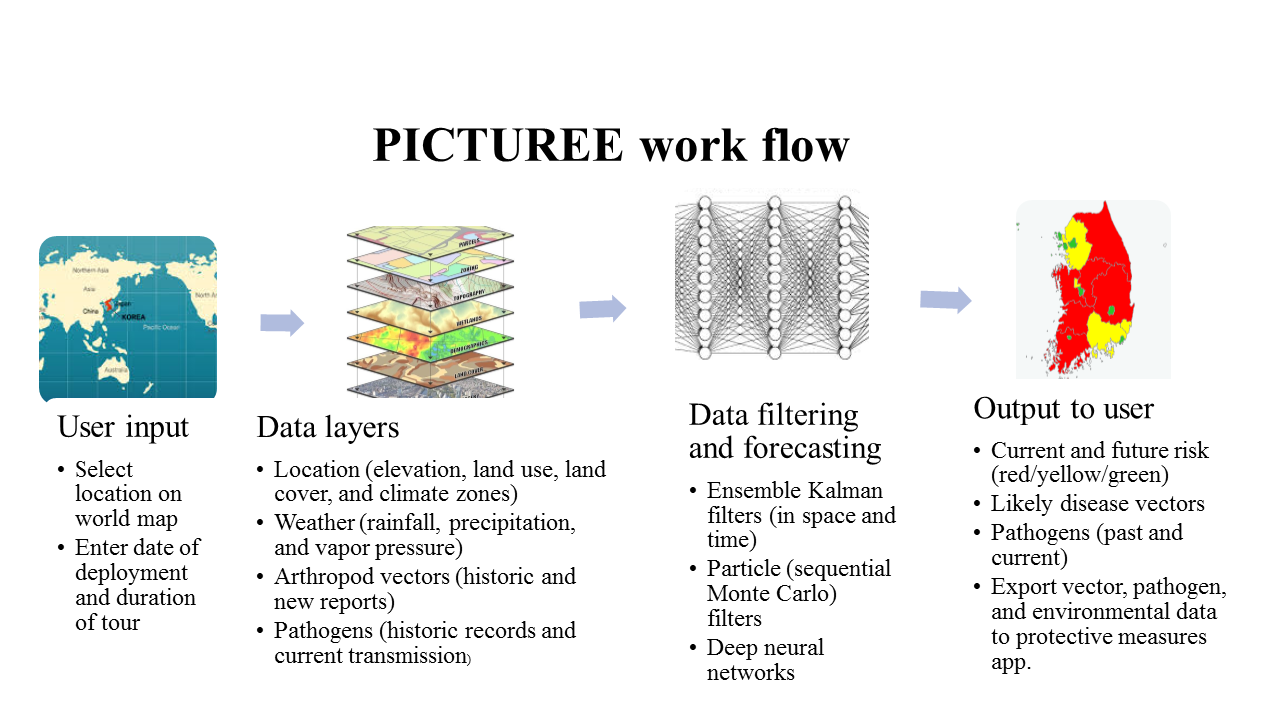
PICTUREE Workflow. The four layers of information include user input, information database, and filtering and forecasting algorithms to generate a summary of risk output for the user based on geographic location, time of year, and mission duration.
Duration July 1, 2019 - July 31, 2023
Investigators
Faculty and Scholar
Caterina Scoglio (Google Profile) (PI) K-State
Aram Vajdi, K-state
Lee Cohnstaedt (co-PI), USDA
Seth Britch (co-PI), USDA
Ken Linthicum (co-PI), USDA
David Pecor (co-PI), Smithsonian Institution
Stephanie Cinkovich (co-PI), Army
PhD Students
Md Mahbubul Huq Riad
Tanvir Ferdousi
Chunlin Yi
Products
Methods
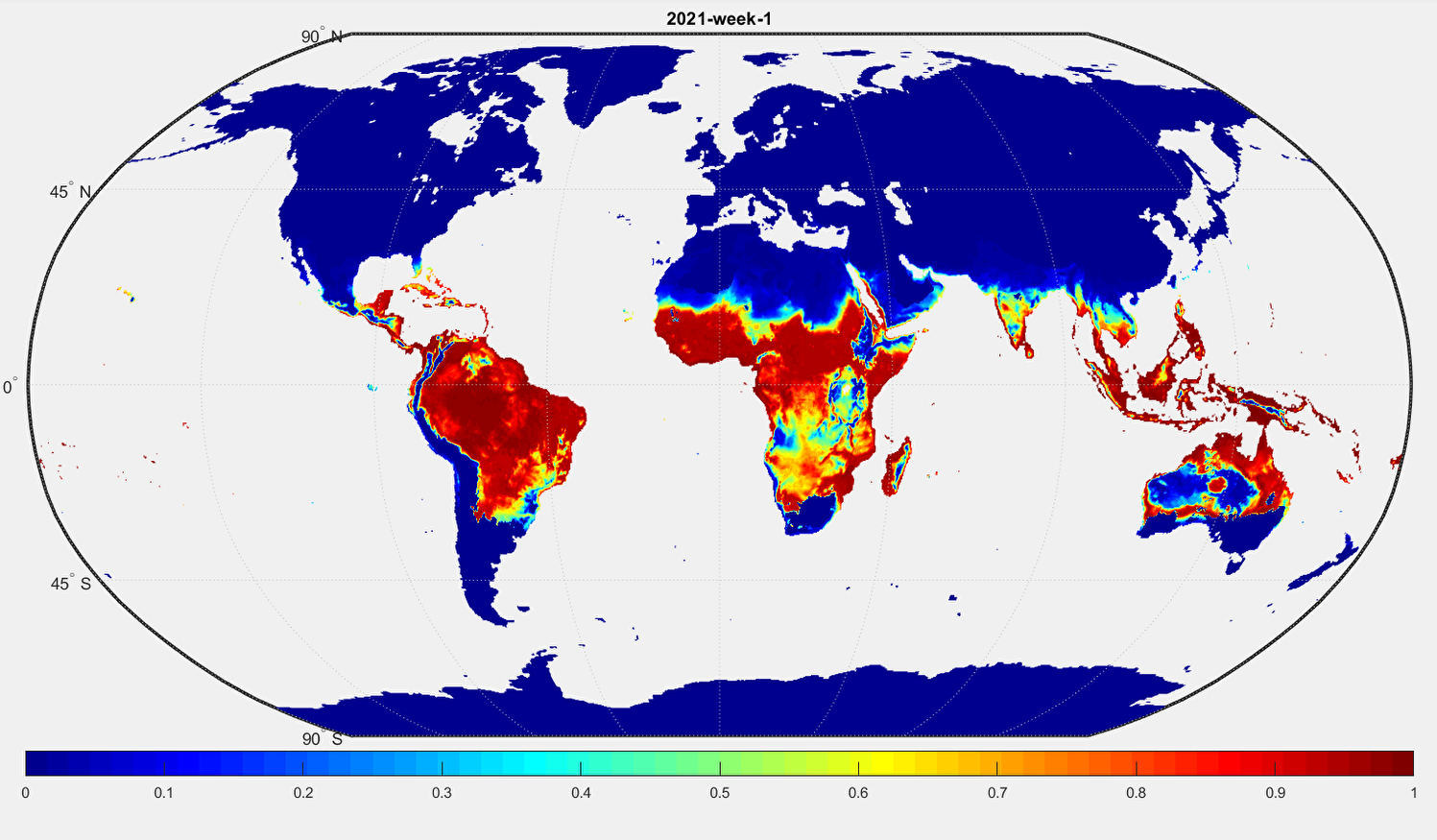
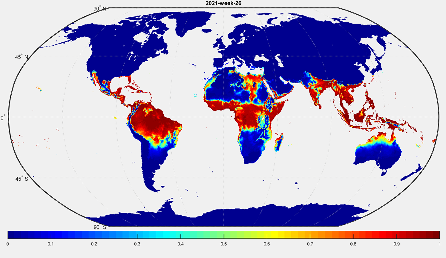
Dengue transmission risk
We use estimated dengue’s basic reproductive number, simulated abundance of Aedes aegypti mosquito, and historical dengue cases around the globe to quantify infection transmission risk. The method uses a novel non-Markovian model to simulate the mosquito life stages, which are greatly affected by the environment temperature. The simulated mosquito abundance and the corresponding disease reproductive number is fed into a risk model that is trained using historical dengue cases. Figures below show dengue transmission potential for the weeks number 1 and 26 in the year 2021.
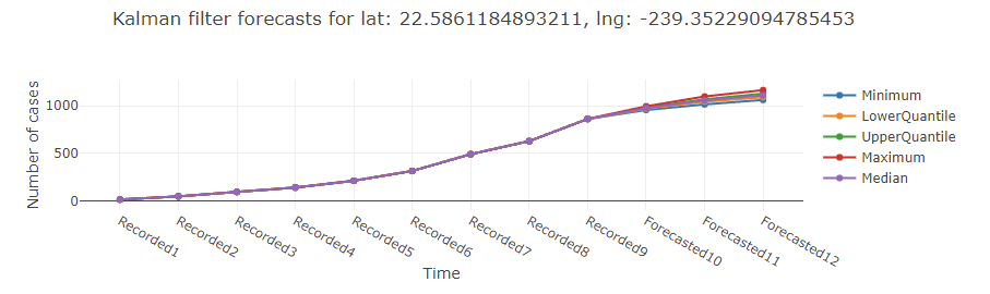
Dengue cases prediction
We have developed three applications for short-term prediction of dengue cases. We use mechanistic models, informed with environmental data, for the transmission of dengue by mosquito vectors, and apply particle filters and Kalman filters to forecast dengue cases. We have also trained an artificial neural network model that uses time series of the simulated mosquito abundance and dengue reproductive number in addition to the case data to forecast future dengue cases.
Software
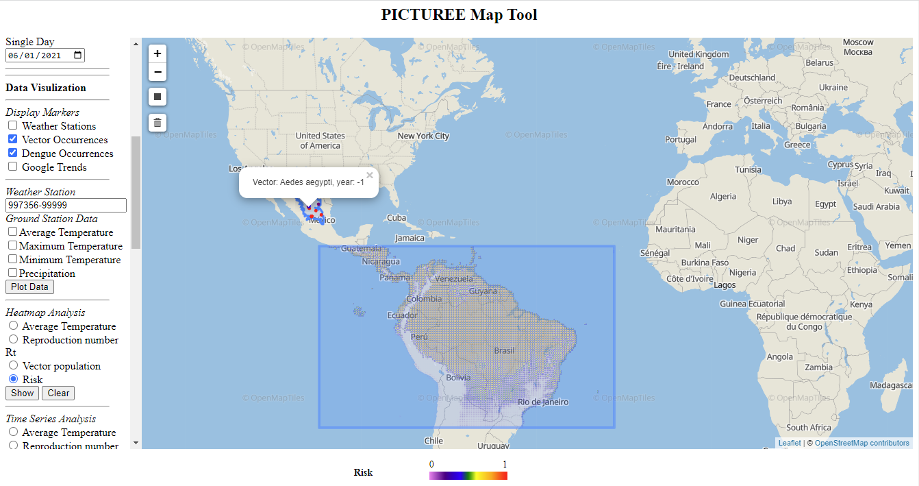
We have developed a web-based map tool software to enable convenient display of spatial and temporal results of our project related to dengue fever. These data may include raw or processed environmental measurements (temperature, precipitation, dengue occurrence, etc) and simulation results (risk, outbreak prediction, etc). The map tool consists of a database, and frontend and backend servers devloped in JavaScript.
Journals
Riad MH, Cohnstaedt LW, Scoglio CM. Risk Assessment of Dengue Transmission in Bangladesh Using a Spatiotemporal Network Model and Climate Data. The American journal of tropical medicine and hygiene. 2021 Apr;104(4):1444.
Yi C, Cohnstaedt LW, Scoglio CM. SEIR-SEI-EnKF: A New Model for Estimating and Forecasting Dengue Outbreak Dynamics. IEEE Access. 2021 Nov 23;9:156758-67
Ferdousi T, Cohnstaedt LW, Scoglio CM. A Windowed Correlation-Based Feature Selection Method to Improve Time Series Prediction of Dengue Fever Cases. IEEE Access. 2021 Oct 14;9:141210-22.
Q. Yang, C. Yi, A. Vajdi, L.W. Cohnstaedt, H. Wu, X. Guo, C.M. Scoglio, "Short-term forecasts and long-term mitigation evaluations for the COVID-19 epidemic in Hubei Province, China", Infectious Disease Modelling, 5(2020), 563-574.
Data
Weather station data
Occurrence data (dengue and vectors)
Daily weather observation (average temperature, maximum temperature, minimum temperature, and precipitation)
Reanalysis data (arevage temperature, reproduction number, vector population, and risk)
Supported by the US Department of Defense, Army. Any opinions, findings, and conclusions or recommendations expressed in this website are those of the author(s) and do not necessarily reflect the views of the DoD